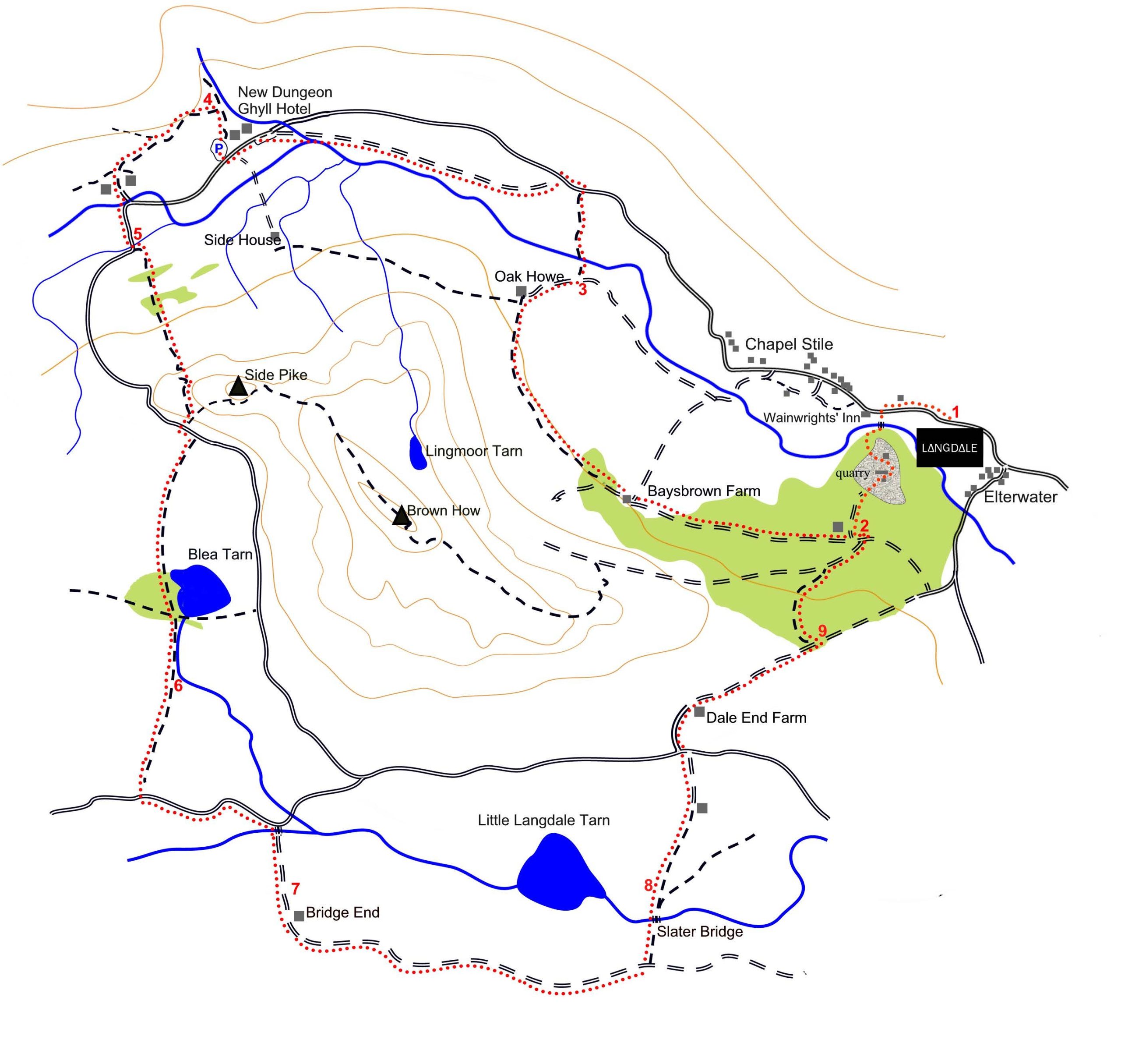
Great & Little Langdale Circle
distance:
7.3 km
difficulty:
easy
ascent:
421 metre
duration:
2.5 to 3 hrs
Summary.
Right on the doorstep Silver How is a lovely walk that can be extended in many directions depending on how you feel or the weather. You can follow our route or use it as guide to make up your own variation which is pretty straightforward. With iconic Lake District views and a perfectly placed refreshment stop on the way home this is a great walk year-round.
Setting off towards Ambleside from the main entrance turn left at the crossroads at the end of the Langdale Estate and follow the road up the hill turning right towards Red Bank and Grasmere until three quarters of the way up there is an obvious path on the left.
Route / description.
- Leave the Langdale Estate by Fellside Gate and turn left along the road. Turn left just before Wainwright’s Inn; cross the footbridge and turn right along the left bank of the river. Shortly after the path passes through a gap in the wall, it starts to bear left away from the river to wend its way upwards between old slate spoil heaps. Passing a house on the left, the path enters the working quarry, where it bends round to the right between the quarry buildings (take care for quarry vehicles) before veering left past the Burlington Slate Office along a track leading gently up into woodland.
- After passing a metal gate, the track reaches a T-junction at a metalled lane, near an isolated house. Turn right along the lane, contouring northwest through mixed woodland of larch and sessile oak. After just over half a mile the lane leaves the woodland briefly to reach Baysbrown Farm. Continue through the farmyard and a gate on its far side, and follow the track – now rougher and mainly unmetalled – towards a second wood. As the track reaches the trees, it veers sharply uphill to the left; turn right here onto a bridleway that undulates through the woods. Eventually the bridleway leaves the woodland and continues along the side of the valley through rough pasture dotted with trees, before gently descending to a T-junction of paths by an old barn. Turn right, following the sign to ‘Great Langdale Road 1/3 mile’. The path bears left past a house called Oak Howe, and becomes a vehicle track.
- As it sweeps round to the right, turn off left to cross a footbridge. Follow a path through fields to reach the Great Langdale Valley road. Turn left and, very shortly, left again onto another track by a post box set into the wall. Follow this as it bends to the right and passes over a beck, heading directly towards the Langdale Pikes. Carry straight on until you reach a small car park. Turn left onto the road and, after only a few hundred yards, right into the National Trust Stickle Ghyll Car Park. Follow the path at the top of the car park, up to the left of the information boards.
- Shortly after passing a National Trust plaque on a boulder, the path forks; take the left fork up a moderate slope and through a gate. Follow the path as it undulates along the side of the valley, with a stone wall on its left, ignoring the path heading up the slope to the Langdale Pikes. After about 1000m you arrive at a crossroads of paths. Ignore those to left and right and go through a gate ahead that takes you down to a metalled lane, over a hump-backed bridge, and to a junction with the Great Langdale Valley road once again. Turn right onto this, taking care for traffic on this narrow section. Follow the road round to the left.
- Just after it crosses another small bridge, take a gate on the left by a Public Footpath sign. This leads you into Great Langdale campsite. Where the gravel gives way to a metalled track, turn right to cross a wooden footbridge and take a path up through fields and stands of larches, eventually climbing the fellside by a series of switchbacks. This is the only significant stretch of uphill on the walk, and is short and sharp. As the path levels out, take a three-stepped stile on the right to gain the road from Great Langdale over to Little Langdale. Turn left onto the road until you reach the cattle grid; turn right, and then left through a gate to follow the path around the western side of Blea Tarn. After passing through the wood along the Tarn’s shore, ignore the paths heading off right into the trees and left across a footbridge: carry straight on through a gate to follow the right side of the beck flowing south from the Tarn.
- After fording two other streams, the path swings away from the river to contour round the flanks of Blake Rigg. The path begins to descend, and then levels off, crossing some rocky stretches as it heads for the Wrynose Pass road. As one nears the road, the path becomes indistinct and marshy, but with only 50 yards to go till you hit tarmac, this is no great problem. Turn left onto the road and follow it down past Castle Howe on the left, and a farm on the right before turning right over the small and picturesque Fell Foot Bridge.
- Follow the track past the cottage of Bridge End, where it bears left and gently ascends. Shortly after fording a stream, the path divides; take the left fork, past a bench and down to gate. The path passes High Hallgarth and descends with slate spoil heaps to the right and a fine view of Little Langdale Tarn to the left; Past the Yorkshire Ramblers Club hut, the track levels off, bounded on the right by more slate heaps. At an ash tree growing from their edge, leave the track by a gate or stile on the left. A short stretch of field brings you to the well-known Slater Bridge, under which the river runs from Little Langdale Tarn.
- After the bridge, keep to the path on the left of the wall, ascending a short steep-ish section with a lovely view back over the tarn. The path levels out through a field to reach a farm. Turn left to follow the track till it reaches the road; turn left and immediately right onto a lane signed “Unsuitable For Motor Vehicles”. Continue past Dale End Farm, as the lane turns back into a track.
- Where the bridleway passes through a gate to descend into woodland, turn immediately left by a stone bench, along a path that climbs gently up the wooded slope. The path then contours round a wooded knoll and descends. Where the path joins a lane, turn left and immediately right. This is now the same track on which you left the quarry early on in the walk. Retrace your steps down through the quarry to the river and footbridge, and so to the road and Fellside Gate.